Saturday, May 28, 2011

Sitka and the turn to the South

Mount Edgecumbe from Sitka Harbour

Last Mango in Sitka
Sitka's history is a fascinating delve into the past. In the 1740's The Russian Empire had established a colony further North in the Aleutian Islands, after explorations by Bering, a Danish navigator who was commissioned by Peter the Great to establish whether Russia and North America were joined. The Russians were primarily interested in the fur trade. Later in the18th Century, various explorers were reaching Alaska from the South - Captains de Hezeta (1775), Cook (1778), Dixon (1787),Vancouver (1792), Valdes (1792) to name only a few. Russian traders discovered that sea otter fur was even more valuable than sable back in Russia and in 1795 they built a fort at Sitka, throwing the local Indians out of their settlement on the very pleasant shores of Sitka sound. In June 1802 the Indians attacked the fort, burning it to the ground and killing virtually all the colonists. The Indians were then in turn attacked and driven out after the Russians returned with an Imperial Warship. Sitka - New Archangel - was the Russian capital of Alaska, and still has its small cathedral and Russian history. Later in the 19th Century, when the profits from the fur trade had declined, and to keep the British out of Alaska, the entire territory was sold to the United States for $7.2m. Sitka is a small town, very scenic, enjoying a wonderful isolated setting on the edge of the Gulf of Alaska. 
Mother earth totem
 The museum, the totem park memorial
Raven war helmet from the battle
to the battle of Sitka, and the raptor
centre were great places to visit, and the weather here in Alaska was excellent. With the freezers full of our fish, we rose early to find a fish boat captain from a neighbouring berth washing Last Mango from a soot discharge. Being very apologetic, he kindly handed us a huge Ling Cod as we left - so Lenny the Ling went into the bath tub to await being turned into steaks and fishcakes.
Finally we have reached the Northernmost point of our Pacific voyage this year and it is time to turn and head South. Leaving Sitka we headed out into the Gulf of Alaska, which was having a benign day. Day 1
Three humpbacks
we must have seen thirty or forty
Prepare to dive.......

humpback whales, usually fishing the tide lines, sometimes broaching, flippering or diving.
The spouts are usually the first sign, then they will surface somewhere and breathe for a
few minutes before diving again. Apparently, after

Preparing..................
migrating here from the South, they spend months feeding in the

Going down.........
rich waters here. In the harbour, the water was teeming with
herring and grilse.
Our journey South took us to
peaceful anchorages on
Coronation Island (named for the accession of George III) and to Exchange Cove, Prince of Wales Island. Now back in Ketchikan, we are just stocking up from Walmart before heading South and back to Prince Rupert, BC. We have very much enjoyed our time in Alaska; we will try to organise more time in the event that we can come back for more.

Tuesday, May 24, 2011

Cod, "Butt and King

These blog posts are coming thick and fast...........from Tracy Arm we headed to Baranof Island and Warm Spring Bay off Chatham Strait. There is a great short hike there, past the hot springs pool where one can soak right next to the rapids and crashing waterfall. The government dock is free to tie up so it does get a little crowded, we were grateful to the folks who budged up a bit to let us in. We fished a while off the dock because a salmon had just been caught but there was no luck for us. The next day we headed off at our usual serious hour to time a transit of Sergius Narrows and made a long run to our next harbour. A walk of the docks yielded the most important information for prospective fishermen - a massive catch being cleaned. Shipper Mike Yanak was happy to offer us places on his next outing at 0515 tomorrow so soon after we were in Salisbury Sound with a rod, line and real bait in our hands. We much prefer proper
What is this?
fishing rather than trolling. It turned
out to be a fantastic day, sunny
Ah.....one of these
 and calm, the weather in Alaska has been better than
anywhere en route so far this year. This Ling Cod was spectacular, fished right off the bottom at about 200 feet.
The bottom fishing was superb and we were catching quite a 
variety of species. There was

 even a Dover Sole which our
guides weren't too keen on but
'Butt of course
 I am looking forward to that
for supper tonight. Our real prey was King Salmon, or Chinook, the most highest prized fish here in Alaska. The method is mooching, where one drops a small dead herring attatched to a weight which slides on the line. The fish
take the bait carefully in their mouths and there isn't a strike. The slider
gives the fish time to take the bait without immediately feeling the weight. This is a very active method of fishing and it also involves driving around in the boat and finding a fish on the sonar and fishing at that precise depth - the reel has a depth counter on it so you know exactly where you are. One unexpected hazard that day was a big dog sea-lion who will eat your fish right off the hook, in the last four days he had stolen 25 Kings hooked up by one boat. Normally he can't catch salmon but he has learned fast. It was a race against time to get your fish on board before he ate it.

Here is how we got on. Maxed out our daily allowance, two Kings each. Fantastic result from an excellent team of Captains Mike and Assam at SE Adventures. If you want this kind of fishing check out http://www.seadventures.com/

The team cleaned our fish and vacuum packed it ready for Last Mango's freezer, along with some bags of pieces for crab bait. Our freezer is totally full...................... king salmon, halibut, and ling cod. Today goes straight into the Top Ten Fishing Days of All Time for us. 

Sunday, May 22, 2011

Tracy Arm: Ice and Bears

We were up early and weighed anchor at 0645, not too much mud to wash off today. What a day, sunny and totally calm. Tracy Arm is a glacial fjord some 25 miles long with two forks at the end each of which has a glacier, the Sawyer. We headed up the channel and into the icebergs, sighting a humpback whale inside the arm; interesting. 
Titanic moment
There was a lot of ice in the arm and pretty soon the radar screen had an
attack of the measles; we had to hand steer all the way up the channel.

Icebergs on the radar
 We were travelling very slowly and every corner we went round the ice was thicker and thicker. I was thinking about giving up but then it seemed to become easier to steer. There was the odd bump from a small piece of ice and I kept wondering what Harris at our haul out yard in Seattle would say if I left any red paint on any of the bergs.

Gin and tonic country
 Actually much of the ice was in very small pieces and the house sized bergs were not difficult to avoid. The worst ones were the translucent chunks, probably the most dense ice from the bottom of the glacier. They sported some nasty looking sharp points so we were careful when they showed up. Finally we made it to Sawyer Island at the junction of the two forks, it was time to float around and look at the amazing spectacle of the glacier.


South Sawyer Glacier

Driving Last Mango through the ice flow was as difficult as positioning these photos on the blog 
Admiral at the glacier
posts!

The journey back was a bit easier,
our faint wake had left somewhat of a cleared path. After exiting the small
area of water at the fork, and on our way back up the arm, we were
surprised to see first a 25 knot cat 
sightseeing cruiser, then the cruise ship Carnival Spirit, then the cruise ship Disney Wonder all disappear 
Cruise ship Carnaval Spirit
behind us into the channel. We were thankful to have had our own secluded time at the glacier and also thankful that Last Mango didn't have to dodge around between those big guys jostling around in there, don't know how they managed to manouvre around.
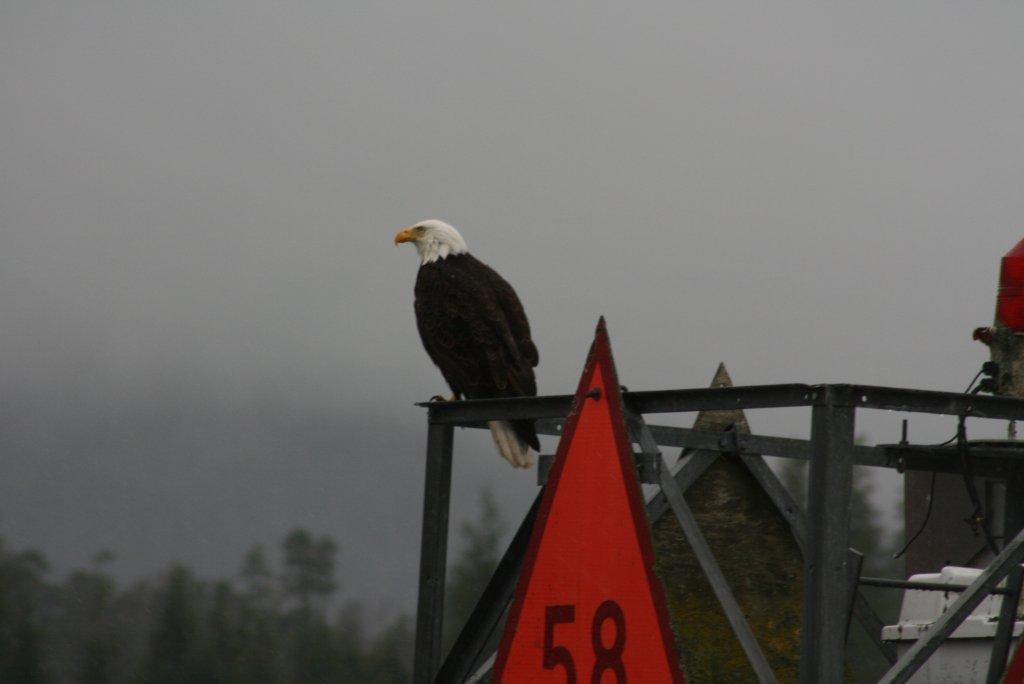

Lonely little guy


While we are travelling we are always scanning the beaches, particularly at low tide, just in case we see something..........yes, there was this lonely little guy checking over a beach for something to eat, a black bear. Finally we have seen our first bear, no doubt there will be plenty more over the coming couple of months that we are going to be cruising in the PNW. 

We headed back into our anchorage at Tracy Arm Cove and were surprised to see that we were not alone..................

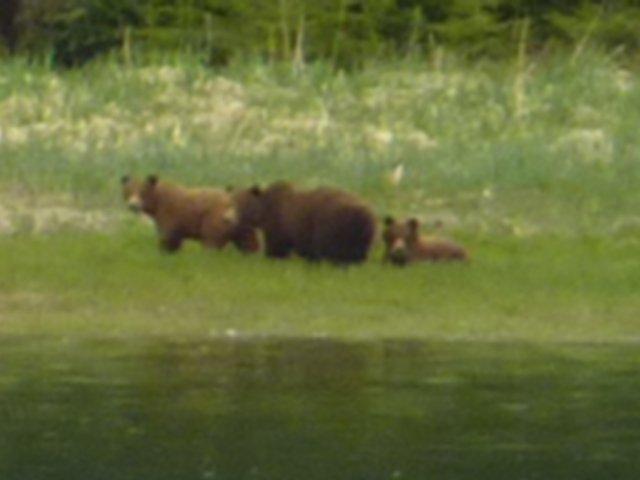
A grizzly sow and three cubs were feeding on the shore. All the noise from dropping the anchor didn't faze them one bit, they just carried on browsing away all round the bay. Our own private grizzly show went on until dusk.


Secure in our anchorage we monitored the radio and heard the cruise
ships making their "securite" announcements at the Big Bend turn and crossing the bar. From our viewpoint we could see these ships with thousands of folk on board passing by.........mama grizzly and cubs carried on rooting around, having the occasional doze, and finally drifting off into the forest.

What a day.


Ketchikan to Tracy Arm

Ketchikan is a mixture of cruise ships and good ole' Alaska homesteading. In the downtown area there are the souvenir shops whereas WalMart is available on the north road. We rested up for a couple of days and enjoyed a burst of warm sunshine while wind of some 25 knots died down. The admiral and I gave the generator some tlc with clean oil and fuel filters all round; feeling virtuous we celebrated at Annabelle's one night and Bar Harbour another. A short way out of town is Totem Bight where there is a wonderful collection of totem poles, only a dollar bus ride to anywhere in town.

Great carving
 Out at totem park there is a great

Long House
collection of totem art and a long house; the site was a sacred place for the Indians
for a very long time; thousands
of years. We caught up with fellow cruisers who were also now in Ketchikan and loaded up with supplies, fuel filters and the like, doing our bit for the local economy. It also gave us time to figure out how we were going to put our Alaska cruise together. We did the first run of 85 miles to Wrangell; leaving at 0505. Two pods of whales in Clarence Strait. Assistant Harbourmaster LaDonna looked after us extremely well (thanks Alex!) and we also loaded up with Multigrade and fuel. Might as well as I guess the price will always go up not down, and it feels good to have full tanks. I had been using the oldest fuel in the two forward tanks to keep turning fuel over; the filter was pretty mucky when switched so it'll be good to have fresh clean fuel.

Moose outfit course planning
Course planning in Wrangell is all about the infamous
Narrows, the route to Petersburg. Foreign 
9pm Ketchikan
 registered boats over 60' get an unpleasant surprise when told that they need to hire a Pilot and fly one in from Ketchikan to transit Wrangell Narrows, more or less the only inside route north. US and Canadian boats are exempt. This "rule" does not bear close examination and no wonder foreign sailors are miffed. Anyway, I am indebted to Greg on Gamapotay (don't ask) for his input on the transit. I even drew a schematic for this one. Ideal times were (a) leave Wrangell 1018 (b) arrive Narrows entrance 1248 (c) 12m on flood tide to 2/3rds up Narrows where slack changes to ebb at 1418 (d) 1 hr on ebb puts you in Petersburg at 1518. We knew it was right when there was a procession of four boats behind and we met another procession at slack in the middle. 

Wrangell navigation jungle
The Wrangell Transit was one instance where an early start was not required. Strange for me really, since if there has ever been any
challenge like writing a difficult
Useful perch
 expert report, preparing for an exam, or making a long journey everyone in my family will tell you that I will be the one up at 5am to do it. This voyage was however very leisurely and, once the planning was done, there where no unpleasant surprises. Susie did get one surprise when,  in a patch of mist, and quite close to an island, a humpback suddenly popped up close to the boat. Another entry for the log, the number of HW sights are increasing daily.

View from our salon in Petersburg
 Petersburg is another pretty place, proud of its Norwegian history.
Sons of Norway, Petersburg
We had time to pay the moorage ($30 dollars seems pretty good to me, although Wrangell was only $17) and visit the museum. Last Mango was rather the rose amongst the thorns in the harbour as you can see on the left. In the morning we headed north into Frederick Sound on a misty day which cleared entering Stephens Passage. 1130 large school Dalls' porpoise which played in our bow wave for half an hour. 1250 one humpback. 1300 two humpbacks. 1310 two humpbacks. 1315 eight humpbacks. 1340 two humpbacks. 1440 first iceberg. 1600 crossed Tracy Arm bar. 1645 dropped anchor Tracy Arm Cove. Cloudy but totally calm. 1700 dinner of BC spot prawn risotto. 2100 Scrabble game ended with just two points in it.

Dall's porpoise

Humpbacks feeding


Saturday, May 14, 2011

The Inside Passage to Alaska

Saturday 7th May we were on our way up the Inside Passage, starting in Fitz Hugh Sound. It was a calm and fairly leisurely day and we travelled some 50 miles at our comfortable 7 knot cruising speed, consuming only 3.5 gallons an hour; that way our range on full tanks is well over 4,000 miles. At 1300 we saw a large school of Pacific White-Sided dolphins and soon after the Alaska ferry Malaspina sped by at 17 knots. We decided to pull up at the dock at Shearwater, more or less the only location with a pub on the Inside Passage. There is a store and a coffee shop run by Louise from Wigan, whose brother has just been made a Silk at 1 Hare Court (small world syndrome). Terry and Judy on their boat "Never" were excellent companions for the evening session at the hostelry.

Ferry "Malaspina" - bigger than us
Needless to say it wasn't an early start. Must have been the pitchers on special. Sunday we ran for 7 or 8 hours and selected Bottleneck Inlet for our anchorage. Running through the narrow entrance we were pleased to see travelling companions the Three Musketeers from Lagoon Cove; we had caught these folks up. And later on another couple of boats came in and joined us. In the morning everyone was up at first light to head for Hiekish Narrows since there would be assistance from the northbound current. As soon as we were in the channel we saw mother and calf minke whale, and we heard reports on the radio from ahead that there was a kermodei (white-coloured bear "spirit bear") but he had long gone by the time we were passing; he was probably turning rocks on the beach at low tide. Just before the Narrows is Ohio Rock, named after the steamship which hit it on 26 August 1909. Realising he was going to sink, the captain turned her around and saved many lives by driving her up onto the beach in Carter Bay.
Debris, mainly logs and trees


We are always on the watch for
An upright log, a deadhead
 logs and other debris while we are under way. Deadheads are the worst, and can damage your boat - particularly if they sink just under the water and seat themselves in the sea floor.
We ran 88 miles that day, and debated which anchorage to head for. There was a wind brewing and so we ended up at very spacious Klewnuggit Inlet. The other choice was Lowe Inlet, but the holding is only gravel, and on 6 July 1793 Captain Vancouver and crew spent a very uncomfortable night there. In the event, the wind did not develop very much and we felt very secure with a few hundred feet of chain out.

Cape Caution is a major hurdle for cruisers and also it represents the end of readily available mooring. For the passage north to Alaska, one passes only decaying canneries and fish packing stations like Butedale, slowly slipping into the sea. For a hundred years from the late 1800's there were around 1,000 canneries on the North American Pacific Coast, now they are all gone along with all the plentiful fish.

Finally, whale pictures
 We saw yet more whales and

Fluke shot
finally Susie managed to get some photos. We saw four pods over the whole of this portion of the trip, and hopefully there will be many more. Our run to Prince Rupert was 51 miles and we tied up at the PR Rowing and Yacht Club. Very friendly place to be, it is one of the very few options in PR. And no ties are required............or jackets...........there is no clubhouse. PR is a small town at the end of Canada. Literally. Unfortunately the pulp mill shut and economic times are bad. In its heyday, PR was a booming railroad town; the name was chosen by public competition for a prize of $250.

From PR it is a fair distance (84 miles) to Ketchikan, Alaska, and one has to pay attention to the weather to cross Dixon Entrance, known for swells and steep seas. There are a couple of refuges on the way if the seas get up. We left at first light, 0540 and headed through Venn Channel out to sea. The Canadian weather forecast was at its usual conservative level and fortunately the sea was pretty flat. More whales, a passing Cruise ship as big as a small city, and we were in Alaska. All our friendly and professional Customs representative needed to do was inspect the fridge and cut open and inspect (a) a red pepper and (b) a tomato. No stowaways were found, so the Alaskan fruit and vegetable growers are safe from our pantry.

Forget the rules of the road!

Sunset at anchor
 It has been a 15-day trip from Vancouver, covering a distance of 614 miles. Layovers at Campbell River, Echo Bay, and Prince Rupert. Used about 500 gallons of fuel. We have seen a lot, learned a lot, met some great people. Stay tuned.                   

Friday, May 13, 2011

Seymour Narrows to Cape Caution

0350 and the alarm went off. Whenever we have an early start we seem to be on the alert all through the night. Well, that part of it that we are supposed to be asleep. I had already done the engine room checks and brought in the shore power the night before so at 0400 we fired up Deere John and we were away from the dock. Moving out of Campbell River we saw another cruiser up and about and it passed through our minds that no doubt they were heading for the Narrows as well. In the channel the flood was still against us; a tug with a tow came through ahead on the dying current, no doubt he had run all night to get his timing right. At the narrows we were dead on time and there was a glimmer of dawn; three fish boats were ahead waiting for the turn and right on cue we were past the site of Old Rip and onto the ebb current into Johnstone Straight, together with the SE wind it was a great start to our journey.

The weather at Cape Caution was poor so the plan was to head into the Broughton Archipelago and do some exploring for a couple of days. First stop was Lagoon Cove where we found two boats who had been waiting a week for good weather to round the Cape; they rose every morning at 0400 to listen to the Canadian weather forecast to no avail. LC was a hoot; our hosts decided to hold the first Happy Hour of the season so at 1630 the day's prawn harvest (a small barrel) was served up along with everyone's culinary contributions. A great opportunity to network with fellow cruisers, including a Nordhavn 50 which has been to Alaska for each of the last 12 years. From Lagoon Cove we headed for Pierre's at Echo Bay. A legendary destination, over some 30 years Pierre has built his clientele (in the High Season of July and August) around the Hog Roast (Sat); Prime Rib (Wed); Italian Night (Mon); Pot Luck (Fri)...........this entirely remote location is a networkers dream in the summer. We were the only boat, and the second of the year so far. We had our own diversions; the prawn traps close by yielded 73 king prawns and the crab trap two keepers in Shoal Bay. Our nest stop was Sullivan Cove where we were the first boat of the year at another stunning location in the Broughtons. From the chart, the Broughtons look like a collection of small islands and channels. But up close, they are just a vast and stunning crusing ground. One could spend a couple of years exploring the area and hardly touch the surface.

Returning crabber

Dungeness crab

At Echo Bay we walked a trail to visit Bill Proctor's museum and home. Bill is a legend of the area; born in 1934 he has never been out of the Province. He has spend a lifetime logging and fishing nearby and collecting relics and artefacts which he has picked up from the local beaches. There are beads which were traded with the Indians by Captains Cook and Vancouver. Glass fish net floats made by Japanese glass blowers who crewed on Oriental fishing vessels. 100 year old magazines and catalogues for the ladies in Victoria. Bone and stone tools from the nearby beach and middens which are thousands of years old. Bill has much insightful observation of the issues which surround BC, in particular involving conservation and the tensions between First Nations peoples and Canadians. He is also very knowledgeable and skilful. Having found a floating cedar log and towed in to his beach, in a mere 14 days he used a chainsaw and a rudimentary splitter to build a replica logger's cabin - the shakes from the log are so smooth you would think they come from a sawmill.

Split from one log with a splitting tool

Modest Bill
Over these few days I had been keeping tuned into the weather to prepare for Cape Caution. A small weather window would develop at the beginning of the weekend. On the Friday morning we headed down Wells Passage to look at conditions in Queen Charlotte Strait. The jigsaw puzzle was falling into place............SE wind 15 to 20knots; Slingsby channel/ Nakwakto Rapids near slack; West Otter Buoy reporting only 2m seas............and there was a tug with a tow a few miles ahead on course for the Cape. It was a good passage with some easy swells, Last Mango took it all in her stride.

Sunday, May 1, 2011

Early Start for Seymour Narrows

Here we are in Campbell River, BC, ready for an early start tomorrow. High tide in the morning here is 0319 in the Canadian Tide and Current Tables. But you have to read the small print, because one tiny sentence on Page 5 says that you need to add one hour for Daylight Savings Time. I'm sure that thousands of people buy these tide tables and never find that out! Why on earth they don't print in the tide tables the actual time on the clocks here in Canada? We will set our alarm early since the plan is to leave on the tide and head the 7.2 miles North to infamous Seymour Narrows. Slack tomorrow is at 0506; it is essential to get one's timing right since by 0833 the current reaches 10.6 knots. Our plan is to pass through the narrows and travel a near 68 mile passage into the Broughton Archipelago, a veritable maze of islands between Vancouver Island and the Mainland, and the guardians of Queen Charlotte Strait. Weather tomorrow is 10 to 20 knots from the South East, essential for a transit of Johnstone Strait on an ebb tide - a North West against the ebbing tide makes for a choppy passage. Tomorrow is our weather window since the wind veers to the North West from Tuesday. And Campbell River doesn't quite have that charm that would deserve a longer visit (sorry CR! - although Dick's Fish and Chips is excellent).

Eagle and seals hitching a ride

Eagle at Campbell River


Our two weeks with the youngsters on board was superb. It was the first time that we had experienced six people on board and we discovered that there really was plenty of room. And plenty to do. Spring has been very uncertain this year here in BC so we opted for a circular cruise around the Strait of Georgia and it was a memorable itinerary. So many good times and great memories; can't wait for the follow up visit soon, especially since we now have a fully honed and drilled Last Mango team. Last week we spent a few days in Vancouver as guests of the RVYC (thankyou!) and enjoyed the top hospitality of the Crosbys (thankyou also!). Finally the weather looked promising so we headed up the Sunshine (!) Coast for an overnight at Secret Cove. We had been spotted there before by Nordhavn Dreamer Mike Pearce so we called him up and gave him the tour with a spin around the cove. Hope to see you around, Mike, maybe in the Gulf Islands later in the year, you never know.

When we approach Seymour Narrows we will remember Captain George Vancouver's words "one of the vilest stretches of water in the world". Ripple Rock (or "Old Rip") claimed 119 vessels and many lives in the period from 1875 to 1958. In the mid 1950's a team of 75 miners and drillers made a 570' shaft, a 2,500 passage under the sea, and two 300' ascending shafts into the twin canines of Old Rip itself. On 5 April 1958, after the largest non-nuclear explosion of the era, Old Rip was lowered from 9 feet under the surface of Seymour Narrows to 47 feet. Phew!

Last Mango is ready to go!